Welcome to the City of Aberdeen’s US 12 Highway-Rail Separation project website.
The City of Aberdeen and WSDOT have been working to solve congestion and access issues along US 12 (Wishkah Street) in East Aberdeen. The City is excited to update you on this crucial project aimed at improving this route. This project is focused on making this route safer and more efficient for the Aberdeen community, visitors, and businesses by making driving easier, improving traffic, and helping emergency services.
The City invites you to explore this website to learn more about what to expect. Thank you for your interest in making East Aberdeen a better place.
About the project
The main goal of the Aberdeen US 12 Highway-Rail Separation project is to improve traffic congestion, safety, and accessibility in the eastern part of the city. These improvements will benefit residents, visitors, businesses, and freight traffic. Over the past two decades, the area has experienced a significant increase in train activity bound for the Port of Grays Harbor that is expected to continue growing. This surge has transformed the US 12 (Wishkah Street) corridor into a bottleneck, impacting traffic to and from the region’s beaches and the city's busiest commercial area (see region map in Figure 1). To address these issues, the project will implement key changes described in the Project Design section below.
The study area for this project is characterized by unique geographic constraints. To the north, steep hills create natural obstacles, while to the south, the Chehalis River works its way towards Grays Harbor, further limiting available space. Within these geographic features lies the US 12 corridor, the Puget Sound & Pacific (PSAP) Railroad, and active commercial areas (see Figure 2). These elements define the boundaries of the project's geographic scope. The project will take into account the complex regional geography and how it affects the flow of traffic and accessibility in the area.

The study area for this project is characterized by unique geographic constraints. To the north, steep hills create natural obstacles, while to the south, the Chehalis River works its way towards Grays Harbor, further limiting available space. Within these geographic features lies the US 12 corridor, the Puget Sound & Pacific (PSAP) Railroad, and active commercial areas (see Figure 2). These elements define the boundaries of the project's geographic scope. This project's geographic focus is important to understand the significance of the proposed changes, as they will directly impact the flow of traffic and accessibility in this complex and dynamic environment.

Continue reading below to learn about the project’s benefits, impacts, and cost.
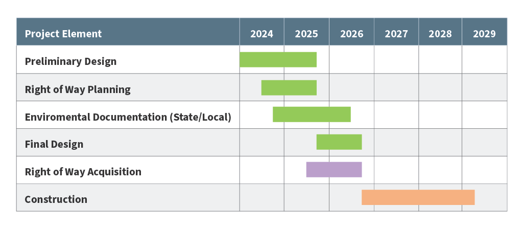
Addressing long-standing traffic challenges on US 12 in East Aberdeen has been a key priority for local transportation, economic development, and elected officials in the region. Planning for this project dates back to 2006, when the Grays Harbor Council of Governments (GHCOG) initiated and secured funding for the US 101 Regional Circulation Project in collaboration with the Washington State Department of Transportation (WSDOT). This project specifically identified the need for access improvements to the commercial areas south of US 12 in East Aberdeen as crucial for regional mobility. See project milestones figure for more details regarding the project timeline, including the estimated start and end dates of construction.
Project Milestones
January 2007
US 101 Regional Circulation Project Final Report (Grays Harbor Council of Governments)
April 2015
East Aberdeen Mobility Project Preferred Alternatives Selection Report
February 2021
Planning Summary Completed
May 2023
Project is Fully Funded
Fall 2026 (Estimated)
Final Design Complete;
Right of Way Acquisition Complete;
Winter 2026 - Winter 2028 (Estimated)
Construction Phase
In 2013, the GHCOG secured funding through the Surface Transportation Program to hire an engineering consultant firm, David Evans and Associates Inc. (DEA), to help them with the East Aberdeen Mobility Project. Working with the City of Aberdeen, WSDOT and the Port of Grays Harbor, the project team developed and evaluated various options to ease congestion and improve safety and accessibility along US 12 in East Aberdeen. As part of this effort, the project team engaged with the community, ranging from individual meetings to open houses, where they discussed design alternatives.
The East Aberdeen Mobility Project culminated in 2015 with the selection of a preferred alternative, the ‘Chehalis Street Overcrossing’ option, which includes the construction of a roundabout at the intersection of US 12 and Newell Street, as well as a grade-separated overpass at Chehalis Street (see Figure 3).

The overpass will allow for uninterrupted access into the commercial area on the south side of US 12 and the PSAP rail line. This will reduce congestion on US 12 by eliminating traffic backups on US 12 while waiting for a train to clear the at-grade driveways into the commercial area (Figure 4).

In the fall of 2017, the city obtained planning funding from WSDOT to further evaluate the East Aberdeen challenges. Project ownership transitioned from GHCOG to the City at this time and the project was renamed to ‘US 12 Highway Rail Separation’. The city continued the partnership with the engineering consulting firm, DEA, to expand on the evaluation of how conditions in the study area had evolved since the preferred alternative was chosen in 2015. The aim was to further refine the preferred alternative concept to align with the changing circumstances. This information was documented in the Planning Summary for the Aberdeen US 12 Highway Rail Separation Project and finalized in February of 2021.
Currently, the City and design team are transitioning from the Preliminary Design phase to the Final Design phase. This work includes gathering current traffic volumes to develop a future expectation of traffic growth, which will be used by the design team to refine the US 12 improvements. The Final Design phase is when all the preliminary planning, concept development, and detailed engineering work come together to create a comprehensive and highly detailed blueprint for the project’s construction. This will include detailed planning, cost estimates, environmental permitting and regulatory compliance, risk assessment, evaluation of impacts to surrounding properties, and outreach to stakeholders and the public. The final design phase is estimated to conclude Fall 2026, and transition to the construction phase in Winter 2026.
The City expresses its deep appreciation to the partners who have made substantial contributions to the inception and development of the project: Grays Harbor Council of Governments, Grays Harbor County, Port of Grays Harbor, and the Washington State Department of Transportation (WSDOT).


Over the last decade, the City and project partners (GHCOG, the Port of Grays Harbor, and WSDOT) have been diligently positioning this project with state and federal agencies to seek funding for the design, right of way acquisition, and construction phases. This persistence paid off in April 2023 when the Washington State legislature identified $72,660,000 in their transportation budget to fully fund all phases of the US 12 Highway Rail Separation project. A summary of the local and state grants used to fund the project is provided below.
| Agency | Grant Amount | Project Phase to be funded |
|---|---|---|
| Washington State Department of Transportation (WSDOT) Rail, Freight and Ports Division | $700,000 |
|
| State of Washington – Connecting Washington (CWA) Program | $72,660,000 |
|
| Port of Grays Harbor | $200,000 |
|
| City of Aberdeen | $200,000 |
|
Project design
The preferred grade-separation alternative selected in 2015 and refined in 2021, identified constructing an overpass near the intersection of US 12 and Chehalis Street with a roundabout at Newell Street to accommodate traffic movements between US 12, the new overpass, and areas to the north of US 12. A key addition associated with the 2021 planning study was the eastbound auxiliary ramp, which provides direct access from downtown Aberdeen to the commercial area south of the rail line (see figure 5).
The City has continued to refine the preferred alternative concept as the project has progressed, based on additional traffic analysis, and coordination with critical stakeholders such as WSDOT and impacted property owners.
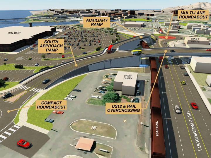
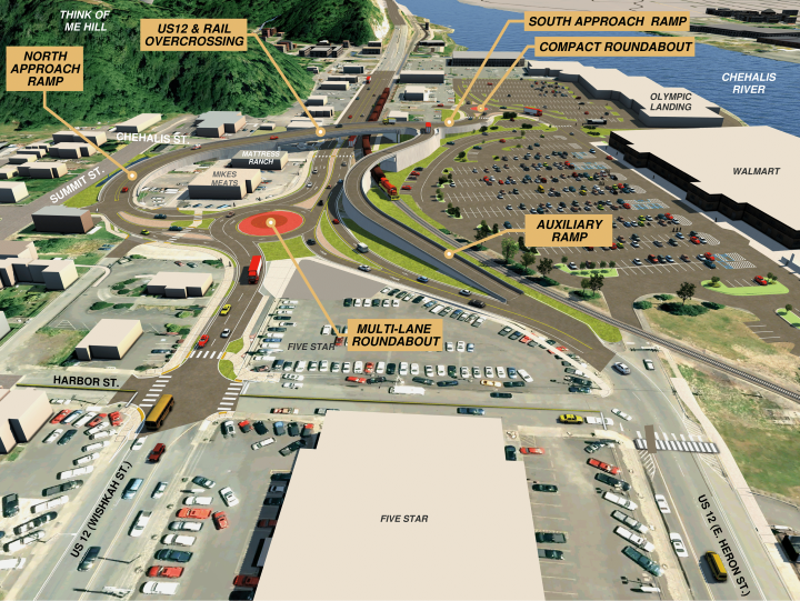
Major components of the preferred alternative to-date include (see Figures 6 through 9):
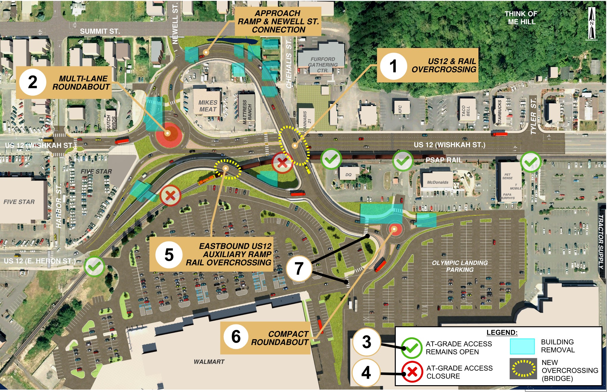
- Add an overpass at Chehalis Street crossing over US 12 and the PSAP railroad (see Figure 7).
- Add a multi-lane roundabout at Newell Street to accommodate vehicle movements between US 12, the new overpass, and areas to the north of US 12.
- Maintain five (5) at-grade crossings of the railroad tracks (at the east terminus of Heron Street; near the Dairy Queen; near McDonald’s; Tyler Street signalized intersection; and Fleet Street) to allow for flexibility and route options when trains are not present.
- Eliminate existing at-grade signalized intersection at US 12 & Chehalis Street and existing right-in-right-out intersection at US 12 and S. Newell Street.
- Dedicated eastbound US 12 ramp (see Figure 8) that crosses over the railroad providing direct access from downtown Aberdeen to the commercial area south of the rail line, reducing traffic volumes entering the proposed roundabout and streamlining US 12 operations.
- Add a single-lane compact roundabout at the base of the Chehalis Street crossing, within the commercial area, to facilitate customer access to Walmart, Dairy Queen, McDonald’s and the Olympic Landing parcels.
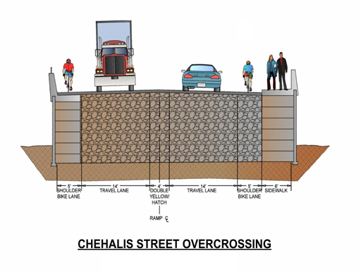
- Provide grade-separated pedestrian and bicycle access along the proposed overpass (see Figure 9).
Project benefits and impacts
Once constructed, the US 12 Highway-Rail Separation project will bring much needed improvements to our community, including:
- Uninterrupted access for vehicles, bicycles, and pedestrians to commercial area south of US 12 and the railroad.
- 24/7 access for emergency vehicles.
- Reduced delays on US 12 due to vehicles waiting for trains that are blocking existing at-grade driveways into the commercial area.
- Improved traffic flow on US 12 by diverting traffic bound for the commercial area onto new grade-separated ramps.
- Improved safety for westbound left turning vehicles into the commercial area by replacing the Chehalis Street signalized intersection with a roundabout at Newell Street (roundabouts reduce the number of vehicle conflict points at the intersection).
Like many urban projects, the US 12 Highway-Rail Separation project will encounter unavoidable impacts to the surrounding area. Impacts can be minimized through creative design decisions. Following are some of the unavoidable impacts, and the City’s approach to minimizing these impacts:
- Property impacts – there are multiple properties, including residential and commercial, that are anticipated to be partially or entirely impacted by the project improvements. The extent of impacts could change as key design elements are further refined during the final design stage. The goal is to evaluate each property and determine if changes to the design can reduce property impacts. The City will communicate any changes to property owners as they arise.
- Environmental impacts – the project is located within a heavily developed urban corridor, and therefore impacts to the surrounding environment will be minimal. The project will evaluate stormwater treatment facility options to reduce the amount of pollutants that would potentially be generated by roadway pavement and enter the nearby Wishkah and Chehalis Rivers as stormwater runoff.
Project costs
As the project design moves from the Preliminary to Final Design phase, development of the property acquisition and construction costs is still a work in progress. The City has pursued and obtained approximately $73 million for the property acquisition and construction phases, based on design assumptions and contingencies made during the Preliminary Design Phase. As the design is refined and property impacts are finalized, the project costs will be updated.
Next steps
The City is currently wrapping up the Preliminary Design phase and entering the Final Design phase. Construction is estimated to begin in late 2026 but is dependent on the duration of the environmental approvals and property acquisition negotiations. Construction duration is directly tied to the complexity and size of the project improvements and is therefore difficult to predict until the Final Design phase is completed. However, based on design assumptions from the Preliminary Design phase, construction is estimated to range from 1.5 to 2.5 years.
The City is committed to keeping you informed as the project team advances through final design. We expect to provide updates to the project website during the Final Design phase, so stay tuned!
Stay informed through our website or contact us as the project advances. Please see the various contact options below.

